
Archive Record
Images
Metadata
Object # |
2006.069.012 |
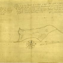
Description |
Reproduction of map of Gooseberry made in 1707; surveyor John Mumford "A neck of land that lyeth a joyning to the south side of the Horseneck in Darthmouth containing 74 acres of land and ponds and land commonly coled and known by ye name of Goosebery neck and ye south end there of by the name of poynt peril, layd out to Christopher Gifford March the 6 day 1707" |
Search Terms |
Gooseberry Neck |
People |
Gifford, Christopher Mumford, John |
Date |
1707 |
Object Name |
Map |
Category |
8: Communication Artifact |
Sub-category |
Documentary Artifact |
Accession# |
2006.069 |