
Archive Record
Images
Metadata
Object # |
2001.139.001 |
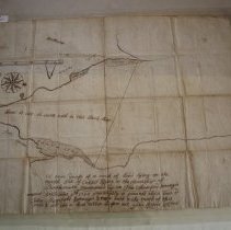
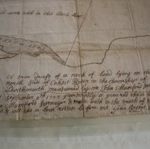
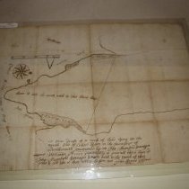
Description |
map of Paquachuck Point, made by John Mumford, September 8, 1707. shows salt water and salt marshes, demarcation line for 60 acres. Westport Point |
Search Terms |
Westport Point |
People |
Mumford, John |
Date |
1707 |
Title |
Map |
Object Name |
Map |
Category |
8: Communication Artifact |
Sub-category |
Documentary Artifact |
Accession# |
2001.139 |